By Aeruxo_DISP_H |
FAA Aircraft Dispatcher Certificate (United States) ·
Korean MOLIT Flight Dispatcher License ·
15+ years active dispatch at a Northeast Asian LCC, ICN hub ·
Graduate researcher, Korea Aerospace University
About the Author →
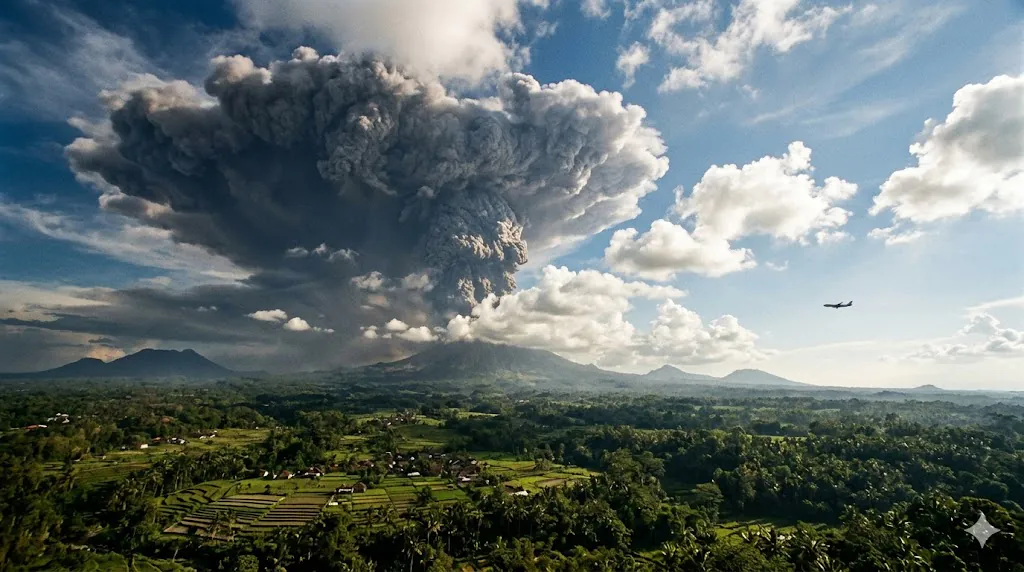
June 2025. Mount Lewotobi Laki-Laki, a volcano on the island of Flores in eastern Indonesia, erupted with an ash column that shot 11 kilometers into the sky. The mushroom-shaped cloud was visible from 150 km away. Dozens of flights to and from Bali — 800 km to the west — were immediately cancelled. Jetstar, Virgin Australia, Singapore Airlines, AirAsia, and Korean carriers all scrapped services. Over a thousand tourists were stranded.
Three weeks later, the same volcano erupted again. This time the ash reached 18 km — well into the stratosphere, higher than any commercial aircraft flies. More cancellations. More stranded passengers. More confusion from travelers who could not understand why their Bali flight was cancelled when the volcano was not even on the same island.
I understand that confusion completely. And I also know, from 15 years of managing volcanic ash disruptions on our Indonesia routes, exactly why those decisions were made the way they were — and why two flights on the same route, departing just hours apart, can have completely different outcomes in the same event.
Volcanic ash is not like other weather hazards. It is invisible to radar, it can destroy jet engines in minutes, and it drifts silently for thousands of kilometers from the eruption site. It is aviation’s most dangerous invisible threat. And the decisions dispatchers make around it are more time-sensitive, more data-dependent, and more operationally consequential than almost any other weather event I manage.
Key Takeaways
- Volcanic ash can destroy jet engines. The microscopic particles melt inside the engine’s combustion chamber, then resolidify on turbine blades — potentially causing complete engine failure within minutes of exposure.
- Ash is invisible to aircraft weather radar. Unlike thunderstorms, volcanic ash does not show up on the radar that pilots use to detect weather. Avoidance depends on ASHTAM advisories, satellite data, and VAAC monitoring systems.
- An eruption 800 km away can cancel your flight because ash clouds drift with upper-level winds, crossing entire flight corridors. The volcano does not need to be at your destination — it needs to be in the airspace between you and your destination, at the altitude your aircraft flies, at the time your aircraft would pass through.
- Why the flight before yours operated and yours was cancelled: volcanic ash moves continuously. The ash cloud that was north of your route at 10:00 may have drifted across it by 14:00. Two flights on the same route hours apart can face completely different airspace conditions.
- There is zero tolerance for flying through volcanic ash. After near-catastrophic incidents in the 1980s and 1990s, the global aviation industry adopted a policy of complete avoidance. If ash is in the airspace a flight must transit, that flight does not operate.
This article is based on real-world flight planning and operational monitoring in an airline Operations Control Center (OCC), including volcanic ash risk management on Southeast Asia routes and real-time ASHTAM monitoring during active eruption events.
1. What Volcanic Ash Does to Aircraft: The Science of Destruction
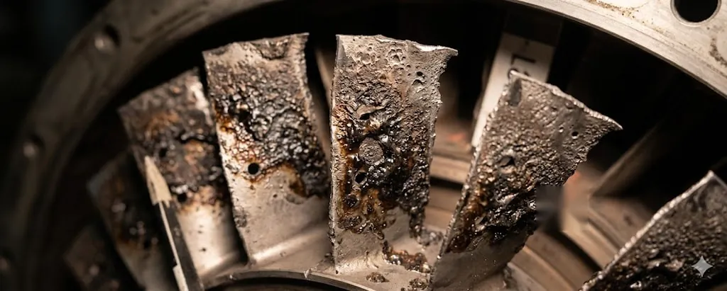
Volcanic ash is not like regular dust or sand. It is composed of tiny fragments of pulverized rock, glass, and minerals — sharp, abrasive particles that are extraordinarily destructive to aircraft systems.
Engine destruction. When ash particles enter a jet engine, they pass through the combustion chamber where temperatures exceed 1,400°C. At these temperatures, the silicate components of volcanic ash melt. The molten material then flows onto the turbine blades and vanes downstream, where the temperature is lower, and resolidifies as a glass-like coating. This coating blocks the cooling holes in the turbine blades, disrupts airflow, and can ultimately cause the engine to surge, lose power, or shut down completely — potentially all engines simultaneously.
Windscreen sandblasting. Volcanic ash particles are abrasive enough to sandblast the cockpit windscreen, reducing visibility to near-zero. Pilots who have inadvertently flown through ash clouds report the windscreen becoming completely opaque within minutes.
Pitot tube and sensor blockage. The fine ash can block the aircraft’s pitot tubes (which measure airspeed) and static ports (which measure altitude), giving the crew erroneous instrument readings — the same failure mode that contributed to Air France 447, applied through a completely different mechanism.
Airframe erosion. The leading edges of the wings, tail, and engine nacelles are eroded by the abrasive particles, similar to industrial sandblasting. While this does not cause immediate structural failure, it degrades aerodynamic performance and requires expensive repair.
The most famous volcanic ash encounter in aviation history is British Airways Flight 9 in 1982. A Boeing 747 flew into the ash cloud from Mount Galunggung in Indonesia — the same volcanic region our routes transit today. All four engines flamed out. The aircraft glided powerlessly for 16 terrifying minutes before the crew managed to restart the engines after descending below the ash cloud. All 263 passengers survived. The incident, and several similar ones in the following years, fundamentally changed how aviation treats volcanic ash. The lesson was unambiguous: volcanic ash and jet engines are incompatible. There is no safe concentration, no acceptable exposure time. The only safe response is complete avoidance.
2. The ASHTAM: What the OCC Monitors in Real Time
Before explaining why your flight was cancelled while the one before it operated normally, I need to explain what the OCC is actually watching during a volcanic event — because the monitoring infrastructure is not widely understood outside the operations community.
The primary document I work with during a volcanic ash event is the ASHTAM — a specialized NOTAM (Notice to Air Missions) issued specifically for volcanic ash hazards. An ASHTAM is issued by the relevant aeronautical information authority when volcanic ash is detected or forecast in controlled airspace. It specifies the affected area in geographic coordinates, the altitude band affected (expressed as flight levels), the source volcano, and the observation or forecast time. ASTHAMs are updated continuously as the ash cloud moves, expands, or dissipates — and during an active eruption event, new ASTHAMs can be issued every few hours.
📋 Dispatcher’s Note — What Real-Time ASHTAM Monitoring Looks Like
During an active volcanic ash event affecting our Indonesia routes, I am checking ASTHAMs continuously — not on a fixed schedule, but every time a new advisory is issued, which can be every 2–3 hours or more frequently during a rapidly developing eruption. Each new ASHTAM tells me: has the ash boundary moved? Has it expanded into new airspace segments? Has the altitude band changed? Has it dissipated in any area that would allow routing? I overlay the current ASHTAM boundaries on our planned routes for every flight in the affected time window and reassess each one individually. A flight departing at 10:00 and a flight departing at 14:00 are assessed against completely different ASHTAM snapshots — because the ash cloud that existed at 10:00 is not the ash cloud that exists at 14:00.
Alongside ASTHAMs, I monitor Volcanic Ash Advisories (VAAs) issued by the Darwin VAAC — the Volcanic Ash Advisory Center operated by the Australian Bureau of Meteorology, which has responsibility for Southeast Asian airspace. VAA advisories include the observed ash position from satellite imagery and a forward forecast showing where the ash is projected to be at 6, 12, and 18 hours. These are the documents that let me plan ahead rather than just react.
Satellite imagery provides the real-time visual picture. VAACs use geostationary satellites with infrared sensors that detect volcanic ash by its spectral signature — ash absorbs and emits infrared radiation differently than water vapor or ice crystals. During an active event, I can pull updated satellite imagery every 30 minutes to see where the ash cloud currently is and how fast it is moving.
SIGMETs — Significant Meteorological Information advisories — are the formal operational trigger. When volcanic ash is detected or forecast in an aviation corridor, the responsible meteorological authority issues a SIGMET that alerts all dispatchers and pilots to the hazard. A volcanic ash SIGMET for Indonesian airspace immediately flags every affected flight on my desk for individual reassessment.
3. Why the Flight Before Yours Operated When Yours Was Cancelled
This is the question I hear most during volcanic disruption events, and it is the question I most want to answer clearly — because the explanation reveals exactly how volcanic ash management works in practice.
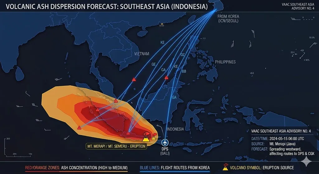
Volcanic ash does not stay still. Once ejected into the atmosphere, the ash cloud is carried continuously by upper-level winds — and at the altitudes where commercial aircraft fly (30,000–40,000 feet), winds can exceed 100 km/h. An ash cloud from a Flores eruption can move 200–300 km in just a few hours. The ash cloud that was east of your flight corridor at 10:00 in the morning may have drifted across it by 14:00. The ash cloud that was at FL350 (above where aircraft fly) at 10:00 may have dispersed to FL280 (directly in the flight envelope) by 14:00.
This means that two flights on the same route, departing from the same airport, can face completely different airspace conditions depending on when they depart — not because one carrier is better equipped, not because one pilot is more skilled, but because the ash boundary moved between their departure times.
📋 Dispatcher’s Note — The Specific Decision I Make for Each Flight
When I assess whether a specific flight can operate during a volcanic ash event, I am not making a general judgment about whether Indonesia routes are open or closed. I am making a specific judgment about whether the airspace that this particular aircraft, on this particular route, at this particular altitude, will transit during its specific time window is free of ash contamination according to the current ASHTAM and VAAC data. The 10:00 departure and the 14:00 departure receive completely independent assessments. If the 10:00 flight’s route is clear but the projected 14:00 ash position shows the corridor contaminated by that time, the 10:00 flight operates and the 14:00 flight is cancelled — even though they are nominally the same route to the same destination. This is not inconsistency. It is the correct application of real-time data to individual flights.
The reverse is also true: a flight cancelled in the morning may be reinstated in the afternoon if the ash clears faster than the forecast predicted. I have reinstated cancelled services mid-day when a VAAC update showed the ash boundary retreating from a corridor that was contaminated four hours earlier. From a passenger’s perspective, this can look inconsistent — a flight cancelled at 08:00 is restored at 12:00 for the 14:00 departure. From my perspective, it is the correct response to updated data.
4. Why a Volcano 800 km Away Cancels Your Flight
The ash does not need to be at your destination. It needs to be in any segment of the airspace your flight must transit — at the altitude your aircraft would be flying, at the time your aircraft would be there. If the ash cloud has drifted into the corridor between Incheon and Bali, even if Bali’s airport itself is completely clear, the flight cannot reach Bali without passing through contaminated airspace. The only options are to route around the ash (if the cloud is narrow enough and additional fuel permits), or to cancel and wait.
During the June 2025 Lewotobi eruptions, this is exactly what happened. The volcano was on Flores. Bali’s airport was technically open. But the ash cloud was positioned directly across the standard approach corridors used by carriers flying from Australia, Singapore, and Korea. The routes to Bali were impassable. As a dispatcher, I do not just check the destination airport weather — I check every kilometer of airspace from departure to arrival for contamination. A clear destination means nothing if the route to it is contaminated.
5. When an Eruption Happens While the Aircraft Is Already Airborne
The scenario I find most demanding — and that passengers almost never know about — is the mid-flight eruption: an aircraft is already airborne, en route to its destination, when a new eruption occurs or an existing ash cloud moves unexpectedly into its projected path.
In this scenario, the crew is managing the flight using pre-departure weather briefing data that no longer reflects current airspace conditions. My role from the OCC becomes critical: I am tracking the updated ASHTAM and VAAC data in real time while the aircraft is in flight, and I must communicate relevant changes to the crew before they enter contaminated airspace.
The communication channel for this is SATCOM — the satellite communication system that allows text and voice exchange between the OCC and the aircraft during flight, even over oceanic areas without VHF radio coverage. If new ASHTAM data shows ash entering the planned route ahead of the aircraft, I send a SATCOM message to the crew with the updated boundary positions and recommend a course of action: deviation around the ash, altitude change to avoid the affected flight level band, or diversion to the nearest suitable alternate airport if avoidance is not possible.
📋 Dispatcher’s Note — Managing a Sudden Eruption With the Aircraft Airborne
A sudden eruption while an aircraft is en route is the most time-sensitive volcanic ash scenario I manage. The sequence is: new ASHTAM or VAAC special advisory arrives → I immediately identify all airborne aircraft in the projected ash zone → I calculate the projected ash boundary position at the time each aircraft would reach it, based on the aircraft’s current position, speed, and the ash cloud’s forecast movement → I send SATCOM to affected crews with updated position data and a recommended action. The crew makes the final decision on evasion or diversion — I provide the data and the recommendation, but the captain has final authority. What I must ensure is that the crew receives the updated information with enough time to act before they reach the ash boundary. A SATCOM sent 10 minutes before ash encounter gives the crew options. A SATCOM sent after they are already in the ash gives them none.
If the destination airport itself becomes affected by ash after the flight has departed, I continuously reassess whether the aircraft can still land there — monitoring updated ASHTAM coverage over the destination, confirming whether the airport has issued a NOTAM suspending operations, and checking the alternate airport’s conditions in parallel. If the destination becomes unavailable, I coordinate the divert decision with the crew and ensure the alternate fuel calculation was adequate. This is live, consequential decision-making with no pause button.
6. Inside the OCC: Managing a Full Volcanic Ash Event
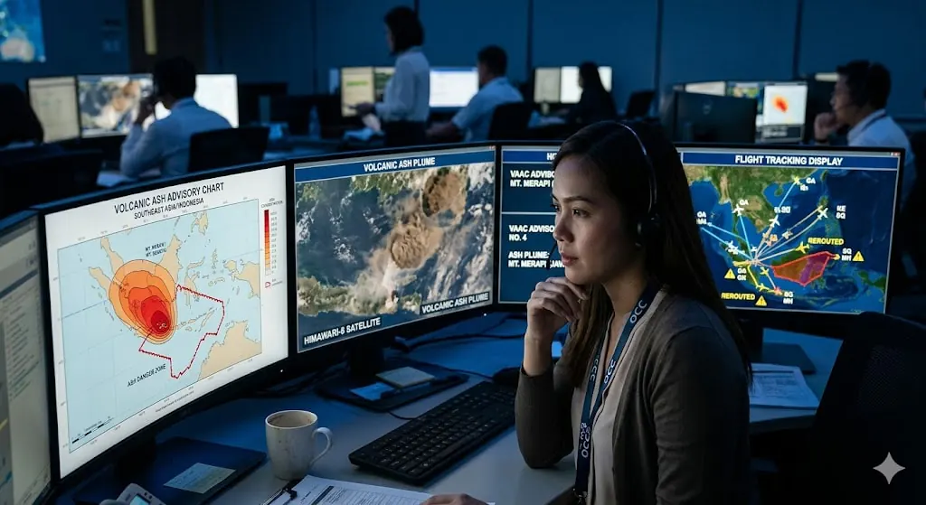
A major volcanic ash event affecting Indonesian routes unfolds in phases from the OCC perspective.
Hour 0 — First notification: A Darwin VAAC advisory reports an eruption at Mount Lewotobi with an ash column to FL350. I immediately identify all flights in the affected time window: which are already airborne, which have pushed back, which are pre-departure, which are scheduled for the next 12 hours. Each category requires a different response.
Hour 1–2 — Assessment and routing analysis: I overlay the current ash position and 6-hour forecast on our planned routes. Can the route fly around the ash? I calculate fuel requirements for deviations. For the standard ICN–DPS routing, a southern deviation to avoid ash positioned northeast of Bali might add 45 minutes of flight time and 2,800 kg of fuel. If the planned payload does not allow the additional fuel, the deviation is not operationally possible. If the ash cloud is wide enough that no deviation is viable, the only option is to cancel and wait.
Hour 2–3 — Flight-by-flight decisions: I assess each scheduled flight individually against the projected ash position at its specific departure time. The 13:00 departure may be cancellable while the 17:00 departure may be viable if the VAAC 12-hour forecast shows the ash clearing from the corridor by that time. These are not batch decisions — each flight gets its own analysis against its own time-specific ash position data.
Hour 6–24 — Monitoring and recovery: New ASTHAMs and VAAC updates arrive every few hours. I reassess cancelled flights against each update. If the ash boundary retreats, I can reinstate previously cancelled services. If the eruption continues or new eruptions occur — as Mount Lewotobi demonstrated with repeated eruptions across 2025 — the assessment restarts from the beginning with each event. Recovery planning includes the domino effects of cancellations on aircraft positions, crew duty times, and passenger rebooking.
7. Indonesia: Flying in the World’s Most Volcanic Country
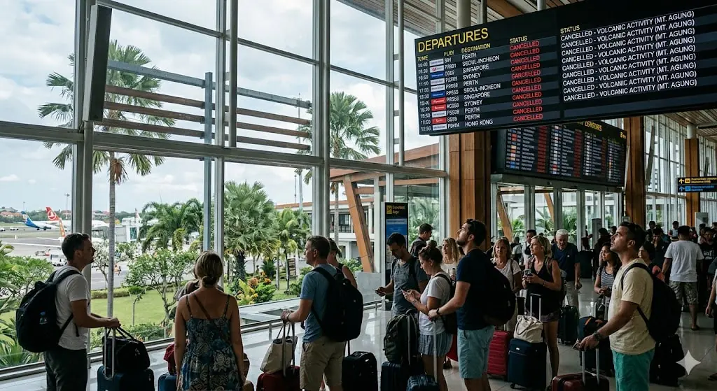
Indonesia has 120 active volcanoes — the highest concentration of any country on Earth. The entire archipelago sits along the Ring of Fire, where tectonic plates converge and create conditions for frequent volcanic activity. For anyone flying to Bali, Jakarta, Yogyakarta, Labuan Bajo, or any other Indonesian destination, volcanic risk is a permanent background operational factor.
The volcanoes that most frequently affect Bali-bound flights include Mount Lewotobi Laki-Laki on Flores (800 km east, erupted November 2024, March 2025, June 2025, and July 2025 — currently the most active threat to Bali aviation), Mount Agung on Bali itself (whose 2017–2019 series caused complete airport closures), Mount Rinjani on Lombok (just east of Bali), and Mounts Raung and Semeru in East Java (which can affect flights approaching Bali from the west — including ICN–DPS services routing over Java).
As a dispatcher with Bali on our network, I maintain awareness of all of these volcanoes simultaneously. Before releasing any flight to Denpasar, I check the latest volcanic activity reports, current ASTHAMs, VAAC advisories, and satellite imagery for the entire Indonesian volcanic belt — not just the nearest volcano. This is a fundamental part of flight planning for Indonesian destinations, not an exceptional response to a crisis.
8. The 1982 Lesson That Changed Everything
The modern approach to volcanic ash in aviation — zero tolerance, complete avoidance — exists because of a single terrifying flight. On June 24, 1982, British Airways Flight 9, a Boeing 747 carrying 263 people, flew into the ash cloud of Mount Galunggung over Java. The crew had no warning — volcanic ash was not well understood by the aviation community at that time, and there were no ASHTAM or VAAC advisory systems.
All four engines flamed out. The aircraft became a glider over the Indian Ocean at night. After 16 minutes of powerless descent from 37,000 feet, the engines restarted below the ash cloud at approximately 12,000 feet. The aircraft diverted to Jakarta and landed safely with heavily damaged engines and sandblasted windscreens. Similar incidents followed: a Singapore Airlines 747 encountered the same volcano’s ash three weeks later, and in 1989, KLM Flight 867 lost all four engines approaching Anchorage through ash from Mount Redoubt.
None of these incidents produced fatalities. All of them came terrifyingly close. The result was the creation of the global VAAC network, mandatory ASHTAM issuance, and the aviation industry’s current policy of absolute avoidance. The system built from those incidents is the same system I use to protect every Indonesia-bound flight I dispatch today.
9. Practical Guide: Protecting Your Trip from Volcanic Disruption
Buy travel insurance. This is non-negotiable for Indonesia. Volcanic eruptions are classified as natural disasters, and standard airline policies provide limited compensation for force majeure cancellations. A comprehensive travel insurance policy covering volcanic disruption — including accommodation, alternative flights, and trip cancellation — is essential for any Indonesian itinerary.
Monitor ASHTAM and VAAC status, not just news headlines. News reports of an eruption do not tell you whether your specific route is affected. The Darwin VAAC website publishes current advisories showing which flight levels and geographic areas contain ash. If you are traveling to Indonesia during a period of volcanic activity, checking the VAAC advisory directly gives you more operationally relevant information than any news source.
Understand that the aircraft before yours and yours may face different airspace. If you see that earlier flights operated normally while yours is cancelled, the ash cloud moved. This is not inconsistency — it is the ash boundary intersecting your route’s time window but not the earlier flight’s. The dispatcher assessed each flight against the ash position at its specific departure time.
Do not assume the disruption will be short. Some volcanic ash events clear within 12–24 hours. Mount Lewotobi erupted four times across 2025, with each event producing days of disruption. Build a buffer day into any Indonesian itinerary, and ensure your accommodation has flexible cancellation.
If your flight is cancelled, rebook immediately through the app. During volcanic disruptions, available seats on alternative flights fill within minutes. Do not wait in the phone queue. Rebook through the airline’s app as soon as the cancellation notification arrives, then document all additional expenses for insurance claims.
Frequently Asked Questions
Can planes fly through volcanic ash?
No. The global aviation industry maintains a zero-tolerance policy for flying through volcanic ash. Ash particles melt inside jet engines at combustion temperatures and can cause complete engine failure. They also sandblast windscreens, block pitot tubes, and erode airframe surfaces. If ash is detected or forecast in any airspace segment a flight must transit, that flight is rerouted around the ash or cancelled.
What is an ASHTAM and why does it matter to my flight?
An ASHTAM is a specialized aviation advisory — a type of NOTAM — issued specifically for volcanic ash hazards. It specifies the geographic area affected, the altitude band containing ash, the source volcano, and the validity time. Dispatchers monitor ASTHAMs in real time during volcanic events and reassess every affected flight against each new advisory. An ASHTAM showing ash moving into your flight corridor at your departure time is the direct operational trigger for your flight’s cancellation or route change.
Why was my Bali flight cancelled when the volcano is 800 km away?
Volcanic ash drifts with upper-level winds, which can carry it hundreds of kilometers from the eruption site within hours. An eruption on Flores can spread ash into Bali’s approach corridors within 6–8 hours. Even if Bali’s airport is clear, the airspace your flight must transit to reach Bali may be contaminated. The ash does not need to be at your destination — it needs to be anywhere on the route between you and your destination, at the altitude your aircraft would fly, at the time your aircraft would be there.
Why did the flight before mine operate when mine was cancelled?
The ash moved. Volcanic ash clouds drift continuously with upper-level winds. The ash boundary that was clear of your route at 10:00 may have drifted across it by 14:00. Each flight is assessed individually against the ASHTAM and VAAC data current at its specific departure time. Two flights on the same route hours apart can face completely different airspace conditions — not because of any difference in the airlines or aircraft, but because the ash cloud has a different position relative to each flight’s time window.
What happens if an eruption occurs while the aircraft is already airborne?
The dispatcher monitors updated ASTHAMs and VAAC advisories in real time and communicates new ash position data to the airborne crew via SATCOM — the satellite communication system that connects the OCC to aircraft during flight. If the updated data shows ash moving into the projected route ahead, the dispatcher sends recommended actions (deviation, altitude change, or diversion) to the crew with enough lead time to respond before reaching the ash boundary. The captain makes the final decision on course of action.
How long do volcanic ash flight disruptions typically last?
It varies. A single eruption with favorable winds may clear flight corridors within 12–24 hours. A sustained or repeated eruption series — like Mount Lewotobi’s four eruptions across 2025 — can produce multiple independent disruption events over weeks or months, each requiring its own assessment cycle. The dispatcher reassesses each scheduled flight against the current ASHTAM data after every eruption event rather than assuming a previous clearance still applies.
Is Bali safe to visit given the volcanic activity?
Yes. The volcanic risk to Bali travelers is primarily a disruption risk (flight cancellations and delays), not a personal safety risk from eruptions on distant islands like Flores. The key is preparation: travel insurance, flexible scheduling, and awareness of current volcanic activity levels before and during your trip. Mount Agung, the volcano on Bali itself, is currently in a non-eruptive phase and monitored continuously.
Planning a trip to Indonesia, or have you experienced a volcanic ash cancellation that left you wondering why your specific flight was affected? Leave a comment — I will answer from a dispatcher’s perspective on what the ASHTAM data was showing at the time.
Disclaimer: The views expressed in this article are my own professional opinions based on 15+ years of operational experience. They do not represent the official position of any airline, aviation authority, or regulatory body.
About the Author
Aeruxo_DISP_H is a licensed aircraft dispatcher holding both the FAA Aircraft Dispatcher Certificate (United States) and the Korean Ministry of Land, Infrastructure and Transport (MOLIT) Flight Dispatcher License. He has 15+ years of active operational duty at a Northeast Asian low-cost carrier operating primarily from Incheon International Airport (ICN) across Japan, China, and Southeast Asia routes. He is currently a graduate researcher in aviation policy at Korea Aerospace University. The views expressed in this article are his own professional opinions and do not represent any airline, aviation authority, or regulatory body.

Licensed Flight Dispatcher with 15+ years of experience in airline operations control. Holds FAA Aircraft Dispatcher Certificate and Republic of Korea Flight Dispatcher License (MOLIT). Specializes in flight watch, NOTAM analysis, flight planning, and operational control at a Korean LCC. IOSA audit participant and author of multiple airline operational manuals, including Emergency Response, De-icing, and OCC Procedures.