By Aeruxo — Licensed Flight Dispatcher | 15+ Years in Airline Operations
As a licensed Flight Dispatcher with over 15 years of experience managing aircraft turbulence and complex weather operations in an airline’s Operations Control Center (OCC), I have handled every facet of flight operations—spanning flight planning, aircraft scheduling, real-time flight watch, and final operational decision-making. Throughout my career, I have planned and guided thousands of flights through some of the most complex atmospheric conditions on Earth, including challenging routes across the North Pacific jet stream and through the Intertropical Convergence Zone. Backed by the latest research and real-world operational data, this article provides a behind-the-scenes perspective on how the aviation ecosystem collaborates to keep you safe.

Key Takeaways
- Aircraft turbulence is a normal atmospheric phenomenon, not a sign of aircraft failure. It is the aviation equivalent of driving over a bumpy road.
- Flight dispatchers and pilots use a layered defense system—from pre-flight weather modeling (GFS/ECMWF) to live PIREPs, SIGMETs, and real-time ACARS data links—to anticipate and avoid severe conditions.
- Modern commercial aircraft are engineered to withstand forces far exceeding anything nature can produce. Wings are tested to flex over 5 meters (16 feet) without failure.
- Climate research confirms clear-air turbulence has increased 55% over the North Atlantic since 1979, making seatbelt compliance more important than ever.
- The single most effective safety measure is simple: keep your seatbelt loosely fastened at all times while seated.
1. Introduction: Why Turbulence Matters Now More Than Ever
For many passengers, the sudden jolt of aircraft turbulence at 35,000 feet is the most anxiety-inducing moment of any flight. In that vulnerable instant, logic gives way to the primal fear of structural failure or loss of control.
But aircraft turbulence has entered the global conversation with renewed urgency. On May 21, 2024, Singapore Airlines Flight SQ321—a Boeing 777-300ER flying from London to Singapore—encountered severe turbulence over Myanmar, resulting in one fatality and over 100 injuries. It was the first turbulence-related death in commercial aviation in over two decades. The incident sent shockwaves through the industry and reignited public awareness about what turbulence actually is—and what it cannot do.
Meanwhile, peer-reviewed research from the University of Reading and other institutions has confirmed that clear-air turbulence is measurably increasing due to climate change. A 2023 study published in Geophysical Research Letters found that severe clear-air turbulence (CAT) over the North Atlantic increased by 55% between 1979 and 2020.
As a veteran flight dispatcher, my daily reality involves analyzing the same atmospheric dynamics that made headlines with SQ321. This article pulls back the curtain on the science, the technology, and the human expertise that work together to keep you safe—even in a warming atmosphere.
2. Understanding Turbulence: A Dispatcher’s Classification
The simplest analogy for turbulence is water flowing through a rocky river. When air encounters obstacles—thermal gradients, mountains, or wind shear boundaries—it creates invisible eddies and swirls. From a flight operations perspective, we classify turbulence by its origin because each type demands a different mitigation strategy.
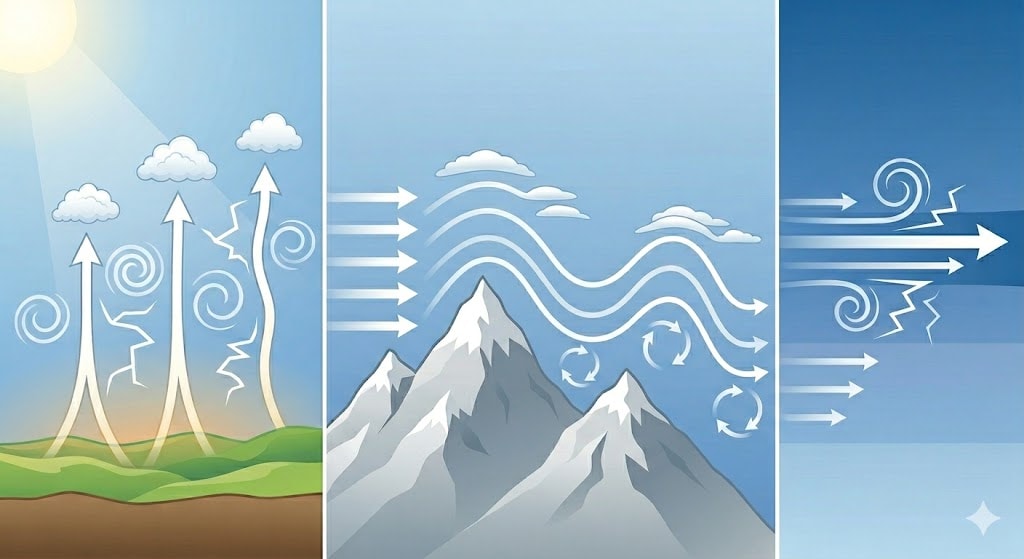
2.1 Thermal (Convective) Turbulence
The sun heats the Earth’s surface unevenly. Dark cityscapes absorb heat faster than reflective forests or water bodies, creating rising columns of warm air called thermals. Aircraft passing through these upward currents experience light, rhythmic bumps—most noticeable during approach and departure on hot summer afternoons. This is the mildest and most predictable form of turbulence.
2.2 Mechanical (Mountain Wave) Turbulence
When strong winds encounter massive topography—the Rockies, the Alps, the Himalayas, or the Andes—the airflow is disrupted violently. Severe vortices and chaotic rotors form on the leeward (downwind) side, sometimes extending dozens of miles from the mountain range. Flight dispatchers map these zones with precision and calculate minimum safe altitudes to route aircraft well above the disturbed layer.
2.3 Clear Air Turbulence (CAT): The Invisible Challenge
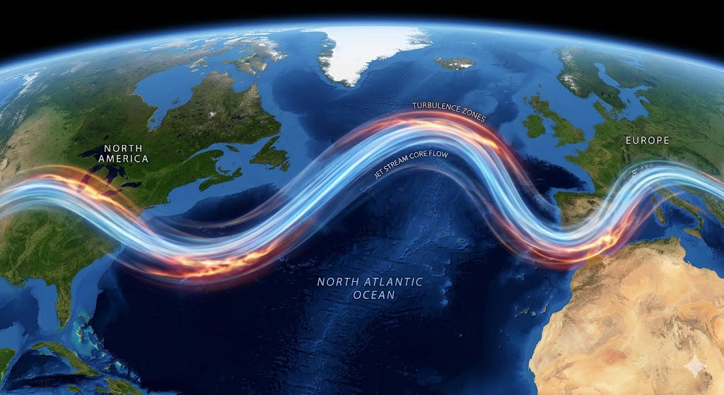
This is the type that generates headlines. CAT occurs at high cruising altitudes (typically between 30,000 and 45,000 feet), far from any visible clouds, and is strongly associated with jet streams—narrow ribbons of extremely fast wind that flow around the globe at cruise altitudes, sometimes exceeding 200 knots.
When an aircraft crosses the steep wind shear gradient between the jet stream core and the slower ambient air surrounding it, it experiences sudden, unpredictable jolts. Because CAT is invisible to both the naked eye and conventional onboard weather radar, predicting it relies entirely on advanced numerical weather models and real-time pilot reports.
Why is CAT increasing? Research published in Geophysical Research Letters (Prosser et al., 2023) analyzed global data from 1979 to 2020 using 21 different turbulence diagnostics. At a typical point over the North Atlantic—one of the world’s busiest flight corridors—the annual duration of severe CAT increased by 55%, from 17.7 hours to 27.4 hours. The mechanism is straightforward: as the tropics warm faster than the poles at cruising altitude, the temperature gradient that drives jet stream wind shear intensifies.
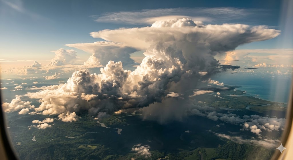
2.4 Near-Cloud Turbulence
This category gained particular prominence after the SQ321 incident. Unlike classic CAT that forms in cloud-free skies near jet streams, near-cloud turbulence radiates outward from developing thunderstorm cells as gravity waves or convective outflows. It can extend 20 to 30 nautical miles beyond the visible cloud boundary—appearing in what looks like clear air.
The FAA recommends maintaining a minimum 20-mile
lateral separation from significant convective cells. However, as the SQ321 event demonstrated, seemingly isolated thunderstorms in their early growth phase can deliver surprisingly violent forces without triggering conventional radar warnings.
2.5 Wake Turbulence: The Man-Made Vortex
Generated by aircraft wings as they produce lift, wake turbulence consists of twin counter-rotating vortices trailing from the wingtips. Air Traffic Control and dispatchers strictly enforce minimum separation distances and time intervals between aircraft to allow these vortices to dissipate. The intensity is proportional to aircraft weight—a fully loaded Airbus A380 generates far stronger wake turbulence than a regional jet.
3. Case Study: What Singapore Airlines SQ321 Taught the Industry
The Singapore Airlines Flight 321 incident deserves careful examination because it illustrates both the limits of current detection technology and the fundamental importance of seatbelt compliance.
3.1 The Timeline
According to the preliminary findings released by Singapore’s Transport Safety Investigation Bureau (TSIB) on May 29, 2024:
- 07:49:21 UTC — The Boeing 777-300ER, cruising at 37,000 feet over southern Myanmar, entered an area of developing convective activity. Vertical G-forces began fluctuating between +0.44G and +1.57G for approximately 19 seconds. An uncommanded altitude increase to 37,362 feet occurred as the aircraft encountered the initial disturbance.
- 07:49:32 UTC — Pilots called out that the fasten seatbelt sign had been turned on. The autopilot, still engaged, pitched the aircraft downward to recover to FL370.
- 07:49:40 UTC — The critical moment: a catastrophic drop in vertical acceleration from +1.35G to -1.5G in just 0.6 seconds. This 2.85G swing in vertical force was sufficient to launch unrestrained passengers and objects into the cabin ceiling.
The entire severe phase lasted under 20 seconds. One 73-year-old passenger suffered a fatal cardiac arrest. Over 100 others were injured, many sustaining spinal cord trauma from the violent vertical displacement. The aircraft diverted to Bangkok and landed safely under its own power.
3.2 The Key Lessons
The aircraft performed exactly as designed. The Boeing 777-300ER maintained stable flight speed of approximately 500 knots throughout the event. The airframe sustained no structural damage. The same aircraft (registration 9V-SWM) returned to commercial service two months later, on July 27, 2024.
The turbulence was near-cloud, not classic CAT. Satellite imagery from Japan’s Himawari-9 showed thunderstorm cells developing rapidly in the area, with cloud-top temperatures dropping to -81.6°C by 08:00 UTC. The turbulence likely originated as a convective outflow or gravity wave from a growing cumulonimbus that was still in its initial development stage—invisible to the aircraft’s weather radar at that specific angle and moment.
Seatbelt compliance was the decisive factor in injury severity. The seatbelt sign had been illuminated for only approximately 8 seconds before the most violent phase. Passengers who were already belted sustained dramatically fewer and less severe injuries than those who were unrestrained.
Current forecasting has a resolution gap. Global turbulence forecast models (GFS, ECMWF) operate at 9-13 km grid resolution—far too coarse to resolve individual thunderstorm cells or the near-cloud turbulence they produce. Furthermore, the area over Myanmar where SQ321 encountered the turbulence was not covered by ground-based weather radar. Closing this detection gap is an active area of research and technology investment across the industry.
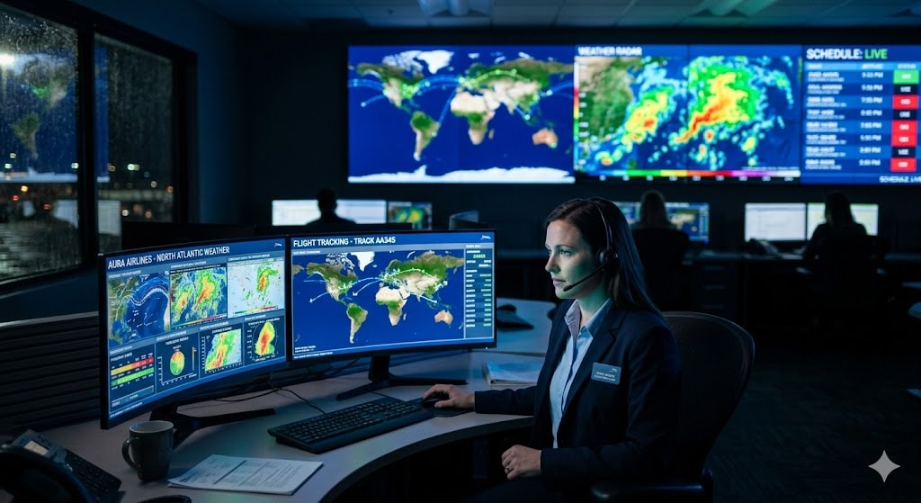
4. The Unseen Network: How Dispatchers and Pilots Collaborate
Before you board your flight, an entire operational ecosystem is already managing your safety. The Flight Dispatcher shares legal joint responsibility with the Captain for the safe conduct of the flight. In the industry, we are known as “the pilot on the ground.”
Learn more about the complete flight planning process in our detailed guide: How Flight Dispatchers Plan Your Route.
4.1 Precision Pre-Flight Planning
Hours before departure, a dispatcher meticulously analyzes global weather data. We synthesize information from multiple layers of intelligence:
Meteorological Products:
- SIGMETs and AIRMETs — Official aviation weather advisories for significant phenomena including severe turbulence, thunderstorms, volcanic ash, and icing conditions. These are issued by designated meteorological watch offices and are legally binding operational references.
- Pilot Reports (PIREPs) — Real-time observations from aircraft already in flight. When a pilot reports moderate or severe turbulence at a specific altitude and location, that data immediately informs routing decisions for all subsequent flights through the area.
- High-Resolution Numerical Weather Prediction — We cross-reference the GFS (Global Forecast System, operated by NOAA) and ECMWF (European Centre for Medium-Range Weather Forecasts) models to predict jet stream positions, tropopause heights, Richardson number instability, and atmospheric wind shear profiles.
Route Optimization: If a severe turbulence zone is forecasted along the planned route—for example, a strong jet stream crossing over the North Atlantic—we have several tools at our disposal. We may detour the flight laterally by hundreds of miles, mandate a different cruising altitude through a step-climb or step-descent to avoid the turbulent layer, or adjust departure timing to miss the peak hazard window. Safety and passenger comfort always take priority over fuel efficiency.
4.2 Real-Time In-Flight Monitoring and Communication
The dispatcher’s job intensifies after takeoff. We continuously monitor flights using satellite-based tracking and leverage several real-time data systems:
IATA Turbulence Aware — An industry-wide platform that automatically collects and shares objective, sensor-measured turbulence data from participating airlines worldwide. Rather than relying solely on subjective pilot reports (which can vary based on aircraft type and individual perception), this system uses onboard accelerometer data to create a global, real-time turbulence map with standardized severity measurements.
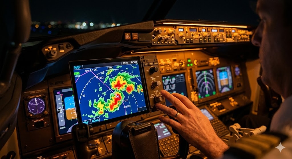
ACARS (Aircraft Communications Addressing and Reporting System) — If a preceding aircraft reports unexpected severe turbulence at a specific location and altitude, the dispatcher immediately sends a digital data-link message directly to the cockpit screens of trailing flights. This message typically proposes a rapid altitude change or lateral deviation—allowing the flight crew to adjust course before reaching the hazardous area, often with several minutes of lead time.
Emerging Detection Technologies — Several airlines and research institutions are testing onboard LIDAR (Light Detection and Ranging) systems that beam laser pulses ahead of the aircraft to detect subtle shifts in air density and wind speed. These systems have the potential to provide 10 to 30 seconds of advance warning for clear-air turbulence encounters—a significant improvement over the current “zero warning” scenario for CAT. Additionally, the Graphical Turbulence Guidance (GTG) model, currently operational in the United States, is being expanded and refined to offer higher-resolution near-cloud turbulence predictions.
5. Built to Bend: The Engineering Safety Net
The question I hear most frequently from passengers is simple and direct: “Can the wings break off?”
From an engineering and regulatory standpoint, the answer is an emphatic no. International aviation authorities—the FAA, EASA (European Union Aviation Safety Agency), and their equivalents worldwide—enforce structural certification standards that are among the most stringent in any engineering discipline.
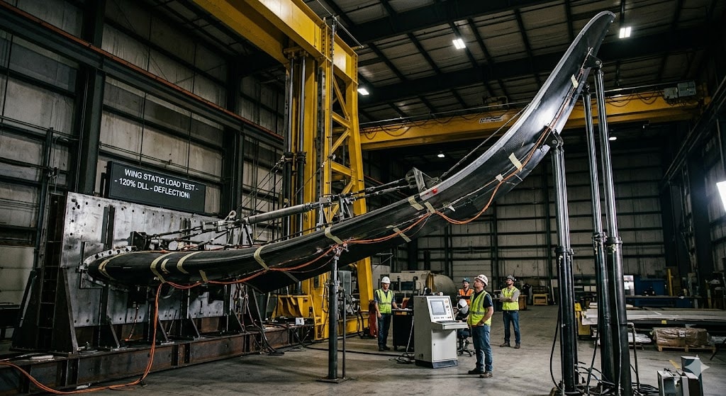
5.1 Wing Up-Bending Tests
Before any new aircraft type enters commercial service, manufacturers conduct static load tests that are among the most dramatic demonstrations of engineering resilience in any industry. Specialized hydraulic rigs pull the wingtips upward to extraordinary angles. The Boeing 787 Dreamliner’s wings, for example, were flexed approximately 7.6 meters (25 feet) upward from their resting position during certification—a degree of bending that looks physically impossible to most observers—without any structural failure.
5.2 The 150% Ultimate Load Requirement
Aviation regulations mandate that the aircraft structure must withstand at least 150% of the maximum load it could ever theoretically encounter during its entire operational lifetime. This is known as the “ultimate load” requirement, and it builds an enormous safety margin into every component of the airframe.
To put this in operational perspective: even the most extreme turbulence encounter on record has generated forces well below this certification limit. The SQ321 event peaked at approximately -1.5G—significant enough to cause serious injuries to unrestrained passengers, but structurally trivial for the Boeing 777’s airframe, which is certified to handle far greater loads.
5.3 Why Flexibility Is Strength
The wings are deliberately designed to flex. If they were rigid, turbulence energy would transfer directly and violently into the fuselage—and to you. Flexible wings dissipate kinetic energy through controlled elastic bending, acting as the aircraft’s suspension system. Modern composite materials—particularly carbon fiber reinforced polymers used in the Boeing 787 and Airbus A350—are specifically engineered for this elastic behavior while maintaining extraordinary strength-to-weight ratios far superior to traditional aluminum alloys.
6. Climate Change and the Future of Turbulence
The relationship between climate change and turbulence was largely an academic topic a decade ago. Today, it has become operationally relevant for every flight dispatcher and airline planner in the world.
6.1 What the Research Shows
Multiple independent, peer-reviewed studies have now established a clear and consistent link between climate change and increasing clear-air turbulence:
Prosser et al. (2023), Geophysical Research Letters: This landmark study analyzed CAT trends during 1979-2020 using 21 different turbulence diagnostics applied to modern reanalysis data. The findings were striking: severe CAT increased 55% over the North Atlantic, with similar significant increases documented over the continental United States, Europe, and the Middle East. This study is widely regarded as the strongest evidence to date that turbulence is already increasing.
Foudad et al. (2024), Journal of Geophysical Research: Atmospheres: Using 11 climate models and comprehensive atmospheric reanalysis from 1980 to 2021, this study found that moderate-to-severe CAT increased between 60% and 155% across various Northern Hemisphere regions. The models project continued increases with each additional degree of global warming, with the highest confidence results over North Africa, East Asia, and the Middle East.
De Medeiros & Williams (2025), Journal of the Atmospheric Sciences: The most recent comprehensive study, using 26 global climate models, confirmed that rising temperatures are intensifying vertical wind shear in the upper atmosphere at typical cruising altitudes. The study concluded that conditions are becoming “increasingly favorable for clear-air turbulence” as the warming trend continues.
6.2 The Physical Mechanism
The physics behind this trend are straightforward. As the tropics warm faster than higher latitudes at aircraft cruising altitudes (approximately 30,000-40,000 feet), the temperature gradient between these regions steepens. This enhanced gradient accelerates jet stream velocities and intensifies vertical wind shear—the volatile shifts in wind speed and direction at different altitudes that are the primary driver of CAT. Since satellite-based observations began in 1979, vertical wind shear in the jet stream has increased by approximately 15%.
6.3 What This Means for Air Travelers
Flights may encounter turbulence more frequently in the coming decades, particularly on North Atlantic, transpacific, and routes crossing East Asia and the Middle East. Some atmospheric scientists project that the average turbulence duration on a transatlantic flight could increase from roughly 10 minutes today to 20-30 minutes within the next few decades.
The seatbelt sign will likely be illuminated more often on these routes. This is not a sign of danger—it is a sign that the monitoring and safety systems are working exactly as intended.
The aviation industry is actively responding with investment in higher-resolution turbulence forecasting, onboard LIDAR detection systems, advanced route optimization algorithms, and improved data-sharing networks that turn every turbulence encounter into intelligence for following flights.
7. The Golden Rule: Your Role as a Passenger
While the aircraft is engineered for incredible structural resilience, there is one critical distinction: unsecured objects—including human beings—are not attached to that structure. This is where passenger responsibility becomes the final and most important layer of protection.
The SQ321 incident demonstrated this with stark clarity: the airframe suffered zero structural damage, but unrestrained passengers were thrown against the cabin ceiling during a 0.6-second G-force reversal that no one could have braced against.

The golden rule is simple: keep your seatbelt loosely fastened at all times while seated.
This single, effortless action provides effective protection against the most common aircraft turbulence-related injuries. You do not need to cinch it tight—keep it comfortably loose over your hips. But make sure it is buckled. Because clear-air turbulence and near-cloud turbulence can strike with little or no advance warning, even when the seatbelt sign appears to be off, the only truly reliable defense is preemptive, continuous compliance.
Additionally, secure any loose items in the seat pocket or overhead bin, and follow cabin crew instructions without delay when the seatbelt sign is illuminated. These are not arbitrary rules—they are procedures refined through decades of operational experience and incident analysis.
8. Conclusion: A Professionally Managed Environment
The next time your flight hits a bumpy patch at cruise altitude, take a deep breath. Know that the dips, sways, and jolts you feel are the dynamic results of a massive, interconnected network of science, engineering, and human expertise—all working exactly as designed.
You are protected by decades of rigorous aeronautical engineering and certification standards that require aircraft to withstand forces far beyond anything the atmosphere can produce. You are guided by a highly trained flight crew with extensive turbulence management training. On the ground, a dedicated flight dispatcher is continuously mapping the atmospheric environment and feeding real-time intelligence to your cockpit. Behind everything is an industry-wide data-sharing ecosystem that transforms every turbulence encounter into actionable knowledge for every flight that follows.
Aircraft turbulence is a natural, inevitable part of the atmosphere we fly through. But expertly navigating it—predicting it, avoiding it when possible, and managing it safely when it cannot be avoided—is our profession. It always has been, and it always will be.
Fly safe. Stay belted.
Frequently Asked Questions
Can turbulence cause a plane to crash?
In modern commercial aviation, aircraft turbulence has never caused structural failure of an aircraft leading to a crash. Commercial jets are certified to withstand aerodynamic forces far exceeding any naturally occurring atmospheric turbulence. However, severe turbulence can cause serious injuries to unrestrained occupants—as demonstrated by Singapore Airlines Flight SQ321 in May 2024, where the aircraft itself was completely undamaged but passengers suffered significant injuries. The aircraft continued flying safely and landed under its own power.
Why is turbulence getting worse?
Multiple peer-reviewed scientific studies have confirmed that clear-air turbulence (CAT) is increasing due to climate change. As global temperatures rise, the temperature difference between the tropics and higher latitudes at cruising altitude intensifies, which strengthens jet stream wind shear—the primary atmospheric driver of CAT. A landmark 2023 study published in Geophysical Research Letters found that severe CAT over the North Atlantic increased by 55% between 1979 and 2020. This trend is projected to continue and potentially accelerate with further global warming.
Which flight routes have the worst turbulence?
Routes crossing major jet streams—particularly the North Atlantic (between North America and Europe) and the North Pacific (between Asia and North America)—tend to experience the most frequent clear-air turbulence. Flights crossing major mountain ranges such as the Andes, Himalayas, and Rockies encounter mechanical mountain wave turbulence. The Intertropical Convergence Zone (ITCZ) near the equator is known for intense convective turbulence, especially during monsoon seasons. However, specific conditions vary daily and seasonally, which is precisely why dispatchers analyze and plan each flight individually.
Are pilots scared of turbulence?
Not at all. For professional pilots and flight dispatchers, turbulence is a routine operational consideration—much like a professional driver navigating a known rough road surface. We have extensive tools to anticipate it, technology to detect and monitor it, and rigorous training to manage it effectively. Our primary concern during turbulence encounters is passenger comfort and the safety of anyone who might be unrestrained in the cabin, not the structural integrity of the aircraft.
What should I do during turbulence?
Keep your seatbelt fastened at all times while seated (even when the sign is off), secure any loose items in the seat pocket or overhead bin, and remain seated if possible. If you are standing when turbulence begins, grab the nearest fixed structure such as a seat headrest or overhead bin frame. Trust your flight crew—they are trained professionals. If turbulence is anticipated, they will secure the cabin in advance. Remember that the bumps you feel represent a tiny fraction of the forces your aircraft is designed and certified to handle safely.
Can pilots avoid all turbulence?
Pilots and dispatchers can successfully avoid most known turbulence using a combination of weather forecasts, real-time pilot reports (PIREPs), satellite data, and onboard weather radar for convective weather. However, clear-air turbulence and near-cloud turbulence remain difficult to detect in advance because they are invisible to conventional radar. The industry is actively developing and deploying new detection technologies—including onboard LIDAR systems that use laser pulses to sense air density changes ahead of the aircraft—to close this critical detection gap.
Have a question about aviation operations or flight safety? Leave a comment below, and I will answer from a professional operational perspective.
Learn more about our mission and operational background on the About Aeruxo page.
Disclaimer: The views expressed in this article are my own professional opinions based on 15+ years of operational experience and publicly available peer-reviewed research. They do not represent the official position of any airline, aviation authority, or regulatory body.